Revalo Balavca
Category
Landscape - Architecture
Date
March 2024
Role
Landscape - Architectural Concept Project
Client

Balavca River Manifesto
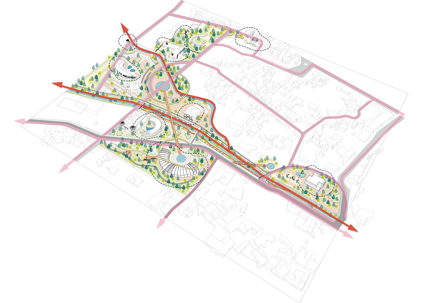
Balavca River is an important element of Milas’s natural, historical, and cultural heritage, and throughout history it has been a significant structure bearing witness to this intersectional heritage as a whole. Both naturally and historically, the stream has served as one of the most important waterways of Milas, where urban life has continued since imperial times. Together with the trace of water, it has also been the source and complement of Milas’s overall urban morphological area. The stream, which forms one of the branches of a significant watershed and meets Milas, has today lost its position within the urban memory and its focus on public use. One of the biggest factors creating this situation has been an understanding that focuses on reductive engineering solutions to rehabilitate Anatolian waterways, rather than prioritizing creative and publicly oriented solutions. The reflection of this understanding in Milas is Balavca River, designed in such a way that it cannot renew itself, with its cultural and historical values pushed into the background, and its relationship with the urban life level severed, ultimately forcing it to be excluded from Milas’s urban identity and embellished with structures that detach it. Intervening in this outcome and forming a set of approaches that will add value to Milas’s identity by harnessing the high potential for transformation along Balavca River’s trace constitutes the main approach of the Revalo Balavca project.
This main approach has been divided into 3 fundamental focuses and sub-intervention groups, aiming to develop an integrated planning approach:
1. The Sustainable Transformation of Balavca River in the Context of Regaining Water
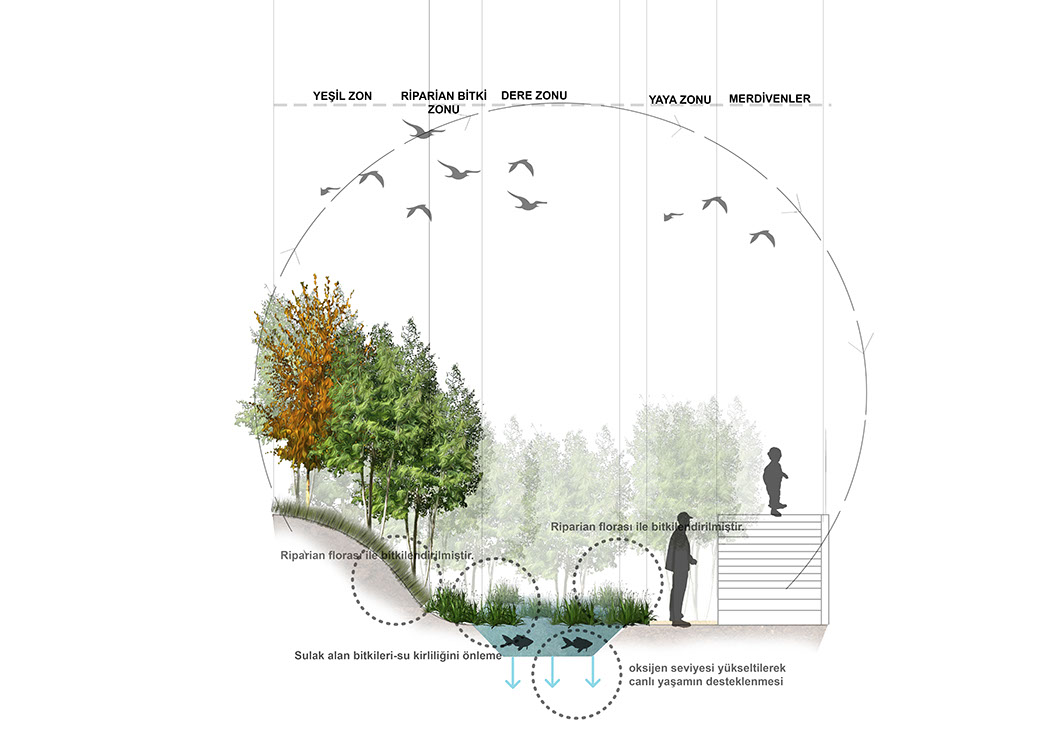
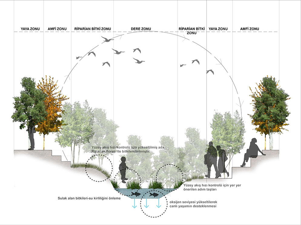
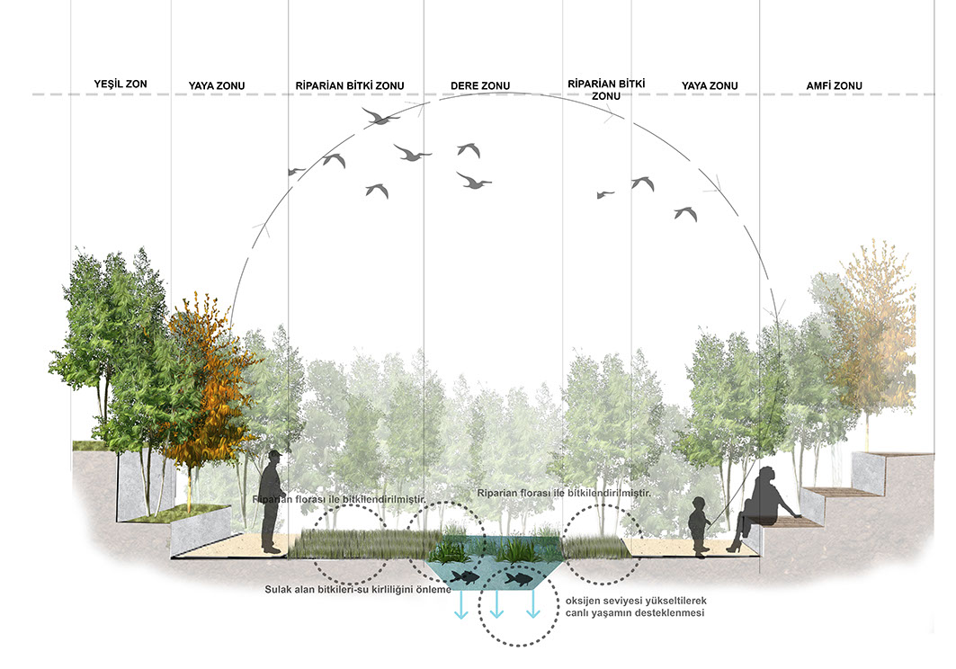
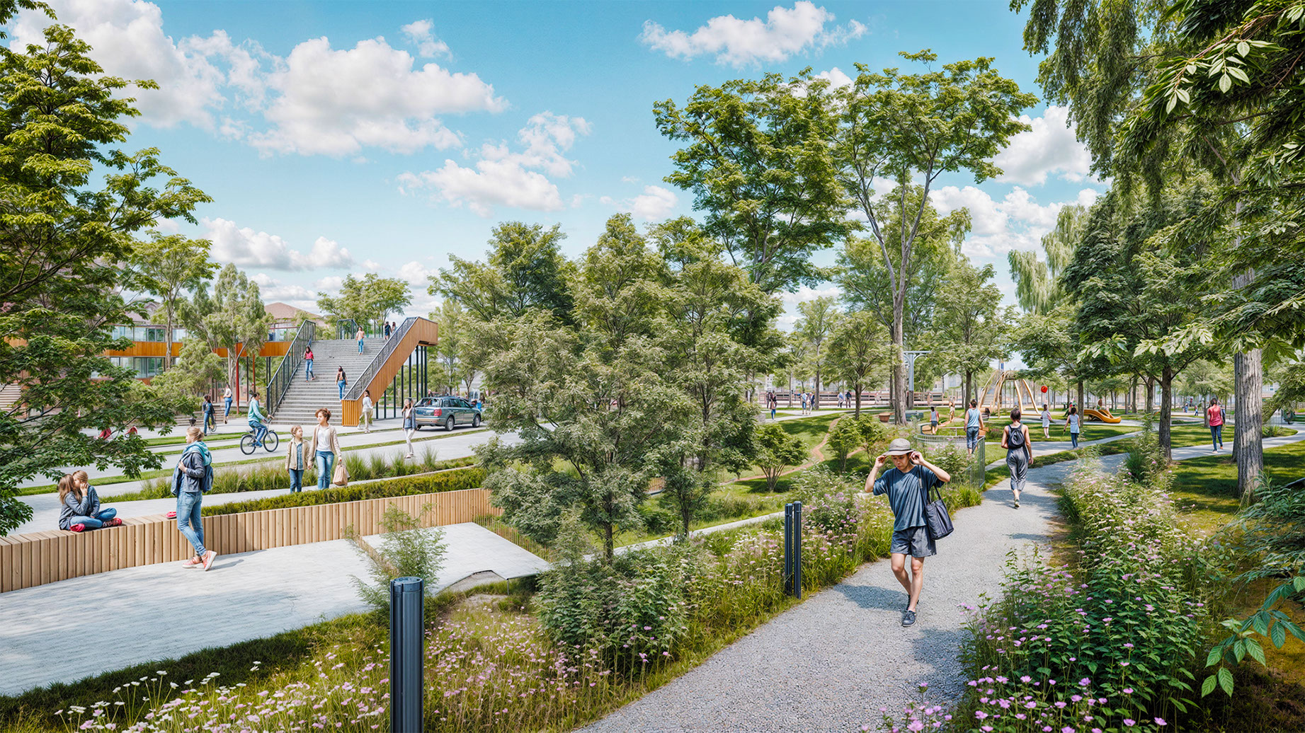
An emphasis has been placed on reorganizing the flow of the stream axis that traverses the entire project area, enabling the flow of water while also foregrounding the rearrangement of urban infrastructure systems alongside water. Through this focus, the flow pattern and regime of the stream have been rearranged, setting up both the flow level of the stream and public usage networks connected to the urban level. With the arrangements made in the stream cross-section, which until now could only be crossed by road, water has been highlighted as a unifying element, thereby increasing urban mobility between opposite banks of the stream.
Additionally, Balavca River has been rendered resilient against risk situations that may arise from global climate change—predicted to impact the Aegean coasts more in the future—and potential disasters associated with the effects of the climate crisis, by incorporating a range of proactive measures. Through design principles that store water, which is highly valuable for the region, and redirect it in the face of risks like flooding, the use of water in the streambed has been transformed into an ecologically sustainable flow.
As an alternative to arrangements that limit the flow and public use of the stream, traffic regulations and a sustainable transportation plan focused on pedestrians and bicycles have been proposed. All existing green values along the stream axis have been preserved and brought to the forefront as a founding element of the new system, aiming to create natural areas where new ecological systems can emerge based on the flow regime of the water. Within this aim, the flora and fauna elements proposed for the area will have spaces that can establish their own cycles and become part of a diversity spiral within the city.
- Redesigning the Streambed with a Focus on Water Flow, Public Use, and Green Axis Continuity
b. Arranging the Stream’s Flow Dynamics to Create Transitional and Usage Spaces at the User Scale
c. Transforming the Stream’s Water Flow into a Form That Can Be Managed with Sustainable Proactive Solutions Against Flooding and Drought Scenarios
d. Converting Vehicle-Based Transportation Solutions Around the Streambed to Suit the New Public Design
e. Removing Unqualified Additions Along Balavca River and Proposing Structural Additions in Line with the New Approach
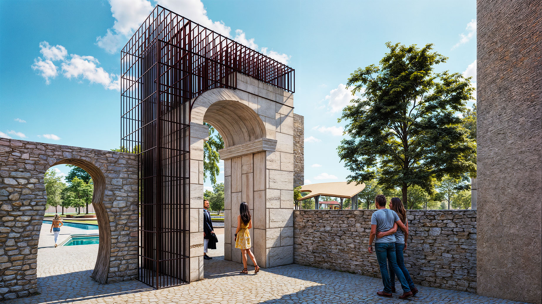
2. The Integrated Design of Historical, Cultural, and Green Areas Around the Streambed
Historical and cultural assets within the project area, each with its own independent qualities, have been interconnected through green axes in ways that are walkable, viewable, accessible, and perceptible for public use. With these routes forming the network of relationships, archaeological sites have been organized as archeoparks, and historical structures have been repurposed with various contemporary functions based on Milas’s demographic structure. Rather than framing these activities within the context of Milas as a selected tourism investment area, they have been shaped to highlight a local-permanent usage approach as an alternative—especially considering that many equivalent Aegean cities do not have a balanced year-round consumption cycle. Along with integrated design elements that reflect the goal of establishing a sustainable urban life, all stakeholders in the city have been configured as part of and supporters of the design activities.
In line with structural proposals that prioritize the transformation of spaces in which all individuals forming society can find a place for themselves, focusing on the balance between people and nature in Milas, the spaces located at the city’s collection and distribution points have been refunctionalized to include new potentials. Points and axes that previously had only administrative buildings have been expanded beyond structures offering limited use, and have been diversified with transitional and complementary new functions, targeting new public usage objectives and user groups.
Thus, all new integrated design areas have been formed through an understanding that evaluates and develops its future internally. The integrated design processes covering these areas have been planned in a participatory and transparent manner to be completed with local materials and construction methods, with the participation of local residents as the main principle.
- Forming Cyclical Urban Routes Connecting Historical, Cultural, and Green Areas
b. Rearranging Archaeological Sites with an Archeopark Approach and Redefining Their Urban Connections
c. Restoring Historical Structures and Refunctioning Them in a Transitional-Complementary Way
d. Adapting Historical Structures That Have Not Survived to the Present Day to Contemporary Functions for Public Life
e. Establishing a Transparent and Participatory Understanding as the Dominant Factor in All Urban Design Processes, Incorporating All Stakeholder Inputs at the Core of the Process
3. Supporting Local Production and Development Goals with Sustainable Economic Proposals and Transforming Industrial Heritage Areas Within This Context
In order to prevent agricultural lands and production potential within the project area from becoming idle against an exclusionary urban formation, it is aimed to continue new production and processing spaces integrated with agriculture in the industrial heritage areas and public focal points of the city. Attached to this goal, a comprehensive rural development-urban function balance has been established, primarily through sub-centers and collection points where different production methods and product types—particularly olives—can be developed. With the integration of advanced technological processes into local agricultural activities, turning into structural proposals, a seed bank for preserving endemic and valuable seeds specific to the city, as well as new vertical and soil-free sustainable urban agriculture spaces and laboratories, have been proposed.
The transformation of public squares, historically corresponding to areas of public use and designated as focal points in the city, has been proposed as a new cyclical beginning in which local crafts and local solidarity-consumption-gathering spaces are designed in harmony. The social activities and reciprocal relationships carried out in these spaces in the past have been transferred to new spaces where possibilities are broadened spatially and usage is sustainably arranged. Taking into account the climatic conditions of the Aegean region and the demographic changes the future may bring, it has been aimed to design these spaces to be as flexible and transformable as possible.
- Creating Public Spaces That Sustainably Support the Production and Consumption Cycle of Local Products and Crafts
b. Designing a Technologically Focused Seed Bank and Alternative Urban Ecological Production Spaces to Preserve Local Agricultural Memory and Guide Its Future Transformation
c. Refunctioning Disused Industrial Structures as New Production and Processing Facilities Under a City-Countryside Balance Initiative
All steps that are part of a sequential system of understanding the area, identifying problems, developing solutions, and proposing implementation are listed below.
Project Team
Nalan Korkut, Sinem Kılıç, Duygu Aydemir, Metin Berk Süer, Rengin Şeşeoğulları